Lower Troposphere Observing System (LOTOS)
The LOwer Troposphere Observing System (LOTOS) is a proposed sensor network to sample the atmospheric boundary layer and land-atmosphere interface.
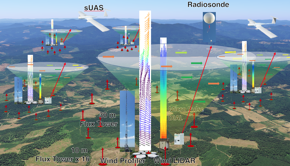
LOTOS will be a transportable integrated network of up to five nodes, each consisting of a suite of profiling instruments surrounded by up to fifteen flux measuring towers. LOTOS will provide novel measurements needed to address outstanding scientific challenges related to processes within the atmosphere, and exchanges of energy, moisture and gases with the surface.
Figure 1. A visualization of a potential deployment of the LOTOS network sampling the boundary layer across a heterogeneous domain.
Executive Summary
The National Center for Atmospheric Research (NCAR) Earth Observing Laboratory (EOL) proposes to develop the LOwer Tropospheric Observing System (LOTOS), a new integrated network of sensors sampling vertically through the planetary boundary layer (PBL) and horizontally across the surrounding landscape. The LOTOS concept builds upon EOL’s expertise in the areas of boundary-layer remote sensing of wind, temperature, aerosol, water vapor, and cloud, as well as distributed surface energy balance, and trace gas flux measurements. LOTOS will provide a much needed thermodynamic profile in the lower troposphere in order to address outstanding scientific challenges in understanding physical processes within the surface layer, boundary layer, and lower troposphere and the coupling of the atmosphere to the underlying land surface. LOTOS also will enable novel quantification of surface exchange of biogeochemically and climate-relevant gases from micro up to regional scale. LOTOS will be part of the deployable Lower Atmosphere Observing Facilities (LAOF) and thus available to both observational and modeling communities.
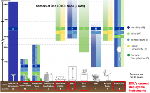
LOTOS consists of up to 5 configurable instrument suites (nodes) comprised of remote sensors for profiles of winds, temperature, moisture, clouds, and aerosols from the surface up to 6 km; a subnet of towers for direct measurement of turbulence and surface exchange up to a height of 30 m; near surface profiles of meteorological parameters and greenhouse gases; 3D tomographic retrievals of the moisture field and automated radiosonde thermodynamic and wind profiles of the troposphere. By remotely measuring winds and thermodynamic profiles from the surface layer through the lower troposphere at high temporal and spatial resolution, LOTOS will provide a wealth of data for process studies and for assimilation by and use in improving advanced numerical weather prediction models. The high-resolution wind field and boundary-layer information provided by LOTOS can be combined with measurements of greenhouse gases and pollutants to quantify exchange at scales not presently attainable. The direct turbulence and eddy-covariance measurements of surface exchange will enable investigations of flux heterogeneity for energy, water, and CO2. Individual components of LOTOS currently exist in various forms at EOL and select research institutions, but LOTOS is unique in simultaneously sampling both horizontally and vertically with an integrated platform. The scalable and configurable nature of LOTOS will allow inclusion of user-provided instruments and future expansion when new measurement technology becomes available. LOTOS offers the potential for transformative understanding of the Earth and its atmosphere as a coupled system.
Figure 2. LOTOS node showing the ranges and measurements of the proposed instruments (not to scale).
Unique Observations Enabled by the LOwer Tropospheric Observing System
- Continuous wind and thermodynamic profiles and their spatial variability to improve understanding and forecasting skill of convection initiation and evolution, including high-impact weather.
- Gradients of mean state variables and related fluxes at high-resolution spatial scales to characterize complex boundary layers (BL), enabling the understanding and modeling of, e.g., transport and exchange processes in flow over complex terrain and planetary BL and aerosol structure over urban areas.
- Quantitative exchange of energy and related quantities between the Earth’s surface, the BL, and the free atmosphere, that will lead to a better understanding of their driving processes.
- Local to regional-scale CO2 fluxes in regions of complex terrain or heterogeneous surfaces, enabling the elucidation of processes impacting ecosystem health and future carbon-climate feedbacks.
- Quantitative regional CH4 exchange including potential transient emissions from thawing permafrost regions, enabling attribution of causes, and better estimates of global climate sensitivity.
- Augmented measurements as required, to improve BL parameterizations and data assimilation in Earth System modeling.
Intellectual Merit
The existing operational atmospheric observing network is insufficient in providing the high-resolution measurements, both spatially and temporally, required for improved understanding for many areas of atmospheric sciences, especially in the lower troposphere where the formation of critical weather systems affects our daily lives. High-resolution observations are needed to understand the complexity and inhomogeneities of the BL, for example of flow over complex terrain or within and above sub-layers of vegetative or urban canopies, of atmospheric stability profiles and their variability that influence moist convective processes, and of horizontal and vertical transport processes. Only recently have new technologies enabled low-cost remote sensing of water vapor and temperature and robust in situ sensing of greenhouse gases. There is an increasing requirement to combine these individual point and profile observations into coherent, three-dimensional, time-varying fields of temperature, moisture, and winds via data assimilation methods for process studies. LOTOS, with integrated observations as shown in Fig. 1, is designed to address these critical observational needs.

