Multiple Antenna Profiler (MAPR)
Multiple Antenna Profiler Radar (MAPR) is an advanced wind profiler radar being developed at NCAR (National Center for Atmospheric Research) /EOL (Earth Observing Laboratory - formerly ATD) to make rapid wind measurements of the boundary layer and lower troposphere. The radar was originally based on a Radian (now Vaisala) LAP 3000 915 MHz wind profiler, however has been highly modified. The MAPR system has now evolved into the 449 MHz Modular Wind Profiler.
The antenna is divided into multiple vertically pointing sub-arrays for reception and uses Spaced Antenna techniques to measure wind. As the atmosphere moves over the radar, the motion of the atmospheric echoes is tracked over the receivers to make a wind measurement. A measurement can be made on time scales of 30 seconds to 5 minutes, which is considerably faster than the 10-15 minutes required by traditional DBS wind profilers. MAPR is generally deployed as part of an ISS (Integrated Sounding System). MAPR can also be run in multiple frequency mode to make FDI RIM (Frequency Domain Interferometry Range IMaging) fine range resolution measurements.
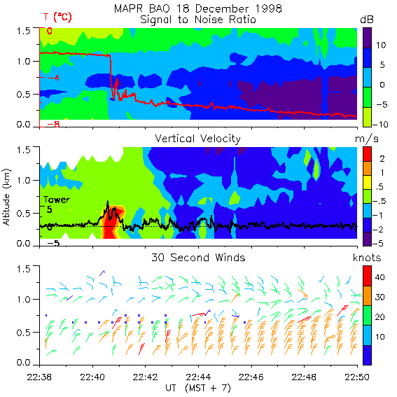
An example of observations with MAPR

This plot shows an Arctic front passing over MAPR at Erie, CO, on December 18, 1998. The three panels show signal, vertical motion, and wind barbs as measured by the radar. The blue shading in the top panels corresponds to snow being brought in by the front. The red trace superimposed on the top panel shows a rapid drop in temperature. The area of red in the middle panel indicates a region of updraft that appears to be a brief but powerful surge of cold air pushed along the leading edge of the front. The wind measurements shown in the bottom panel were made at a rate 10 to 20 times faster than is possible with conventional profilers. As can be seen this instrument opens up exciting possibilities for studying rapidily evolving weather events.
MAPR specifications
| Frequency | 915 MHz (33 cm) |
|---|---|
| Transmitter | 3.5kW peak, 400W average |
| Receivers | 4 PIRAQ II data cards |
| Range | Typically to 4 km in warm, humid clear-air conditions 2 km in cold, dry clear-air conditions Sees right through depth of precip (say up to 10 km) |
| Resolution | 50, 100, 200 meters FDI RIM available for 10m scale resolution |
| Platform | Ground based - 20' container hauled by truck Can be operated at sea with stabilized platform |
| Measurement | Rapid (1 minute) wind measurements using spaced antenna techniques, Reflectivity, Doppler Velocity, Turbulence Intensity, RASS temperature profiling |
| Data Recording | Raw data: netCDF on DVD or RAID disk (5-20 GB/day) Wind products and images near real-time on Web |
| Operational Limitations: | Low clutter environment preferred |
| Applications: | High time resolution measurements of wind in the boundary layer Turbulence and Precipitation studies Particularly suited for rapidly evolving events, e.g., fronts & squalls Flux measurements under development |
More Links:
Abstract of Cohn et al [1997] which presented the first high time resolution measurements made with MAPR
Abstract of Cohn et al [2001], paper describing clear-air measurments made with MAPR
Refs
Cohn, S.A., C.L. Holloway, S.P. Oncley, R.J. Doviak and R.J. Lataitis, "Validation of a UHF spaced antenna wind profiler for high resolution boundary layer observations", Radio Sci, 32, 1279 - 1296, 1997.
Cohn, S.A., W.O.J. Brown, C.L. Martin, M.E. Susedik, G. Maclean, and D.B. Parsons, "Clear Air Boundary Layer Spaced Antenna Wind Measurement with the Multiple Antenna Profiler (MAPR)", Annales Geophysicae, 19(8), 845 - 854, 2001.
CONTACTS
Science:
Bill Brown, Email: wbrown@ucar.edu
Engineering:
John Sobtzak, Email sobtzak at ucar.edu
Software:
Gary Granger, Email: granger@ucar.edu
MAPR development is supported by NCAR/EOL. Previous support has also come from the Department of Energy VTMX and ARM programs and Radian.