IOP 10: 08-09 February 2001
Time Period of IOP
0400 UTC 08 Feb. 2001 - 1818 UTC 09 Feb. 2001
Overview of IOP
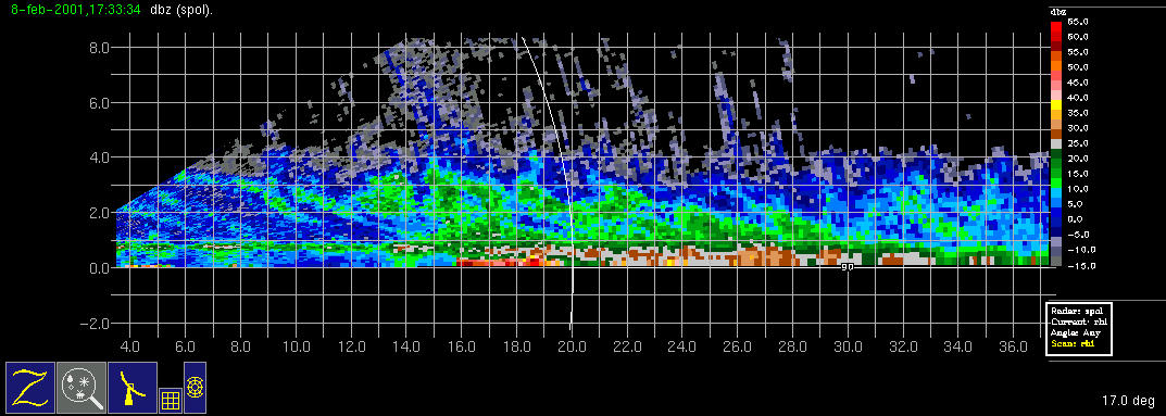
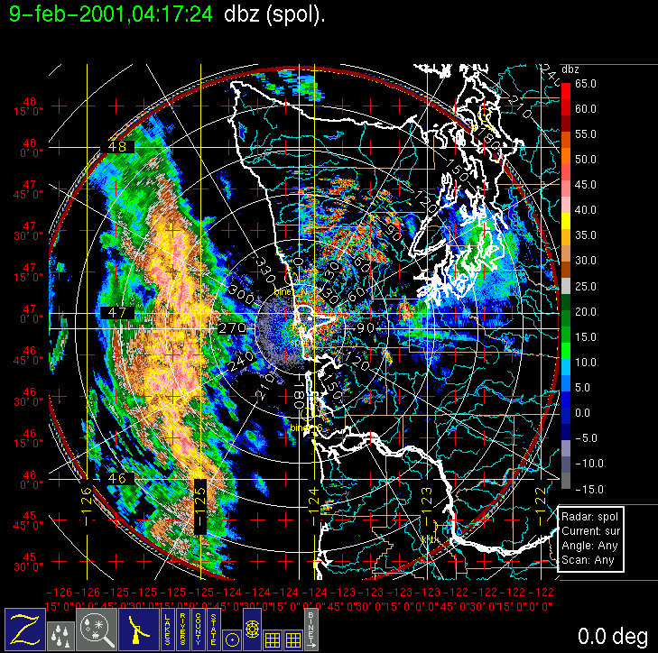
On (Wednesday) 7 February 2001 the forecast models predicted that a surface low-pressure center would develop in northwesterly flow and pass through the study area on (Thursday) 09 February, with a warm-frontal-type precipitation band in the morning and a cold-frontal-type precipitation band in the late afternoon. A Convair-580 flight was called for with a doors closed time of 7 am local time on Thursday morning, with the likelihood of two flights being attempted to capture both precipitation systems. However, an aircraft mechanical problem surfaced on Wednesday evening, precluding the possibility of a Thursday morning flight. The morning rainband was an interesting case, with a vertical cross section (S-Pol RHI) showing very nice generating cells aloft and sloping virga streaks falling into heavier clouds and precipitation below. The aircraft was ready for take-off by 6 pm local time Thursday and was able to intercept a second rainband that stalled off the coast during the early evening. Several legs were flown from the surface to 15,000 ft at 2,000 ft. intervals.
Convair-580 Summary
UW Flight Number:
1858
Period of Flight:
0153-0655 UTC, 8 February 2001
Main Accomplishments of Flight:
Measurements in rainband associated with occluded front.
Instrument Problems:
Some SPEC HVPS dropouts.
Flight Scientist:
Peter Hobbs
Approximate UTC Timeline (Local time = UTC – 8 hours) Activity for UW Flight 1858:
0153 Engines on.
0205 Take off from Paine Field. Ferry—instruments okay.
0234 Begin low-level leg. Initially 4,000 ft to 2,000 ft.
0252 Windshift and precipitation (heavy) onset.
0305 End of low-level leg
0308 Start of 3,000 ft run (climbed to 3,500 ft early).
0327 End of 3,000-3,500 ft.
0329 Start of slow ascent 3,500 to 5,500 ft.
0342 End of ascent 3,500 to 5,500 ft.
0343 Start of 5,500 ft.
0400 End of 5,500 ft.
0403 Start of 5,500 to 7,500 ft ramp.
0415 End of 5,50 to 7,500 ft ramp.
0419 Start of 7,500 ft.
0435 End of 7,500 ft.
0437 Start of 7,500-9,500 ft.
0452 End of 7,500-9,500 ft.
0455 Start of 9,500 ft.
0510 End of 9,500 ft.
0513 Start of 9,500-11,500 ft.
0527 End of 9,500-11,500 ft.
0531 Start of 11,500 ft.
0535 Begin climb at 200 ft/min (as part of eastbound run).
0545 End.
0549 Start of 13,500 ft.
0557 End.
0601 True air speed malfunction.
0602 Start of 16,500 ft.
0610 End of 16,500 ft.
0648 Touch down at Paine Field
0655 Engines off.
S-Pol Radar Summary
Scan cycle switched from NWS-Surveillance to Long Range with RHIs.
1500 UTC Thur 08 Feb.:
Scan cycle switched from Long Range to NWS Surveillance plus RHIs.
1900 UTC Thur 08 Feb.:
1930 UTC Thur 08 Feb.:
Scan cycle switched from Research to Long Range plus RHIs.
0300 UTC Fr 09 Feb.:
Scan cycle switched from Long Range to Research.
1818 UTC Fr 09 Feb.:
Summary of Navy Sonde Launches from Westport
1452 UTC Thur 08 Feb.
1755 UTC Thur 08 Feb.
2048 UTC Thur 08 Feb.
2350 UTC Thur 08 Feb.
0249 UTC Fr 09 Feb.
0548 UTC Fr 09 Feb.
Note: One test launch performed by AG2 Schmid on arrival on 03 or 04 Feb.
Summary of NWS Sonde Launches from Quillayute (UIL) and Salem (SLE):
UIL Launch Times:
SLE Launch Times:
1400 UTC Thur 08 Feb. (special)
1800 UTC Thur 08 Feb. (special)
2000 UTC Thur 08 Feb. (special)
0000 UTC Fr 09 Feb. (standard)
0200 UTC Fr 09 Feb. (special)
0600 UTC Fr 09 Feb. (special)
0800 UTC Fr 09 Feb. (special)
1200 UTC Fr 09 Feb. (standard)
Notes: 1) Quillayute was not operational during IOP 10 due to an equipment malfunction.
2) One sonde was launched at Salem at 2000 UTC Sun 04 Feb. because that day's operations were canceled at the
last minute, and the sonde flight was not canceled in time.
IMPROVE (University of Washington)

