IOP 11: 13-14 December 2001
Time period of IOP
2040 UTC 13 Dec-0815 UTC 14 Dec
Overview of IOP
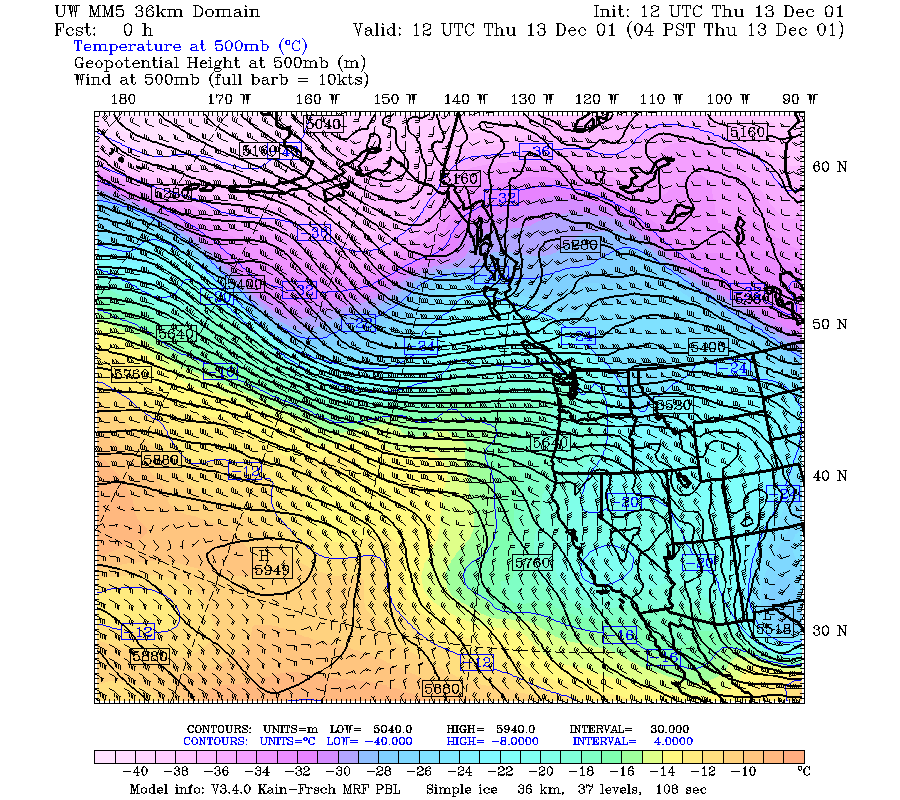
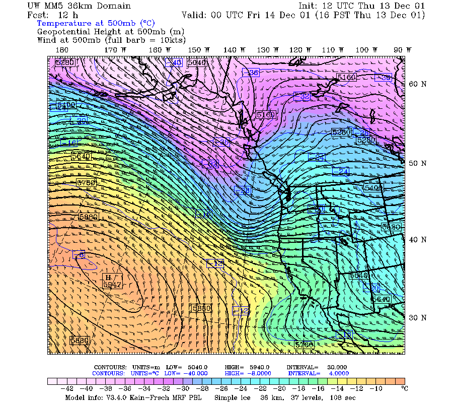
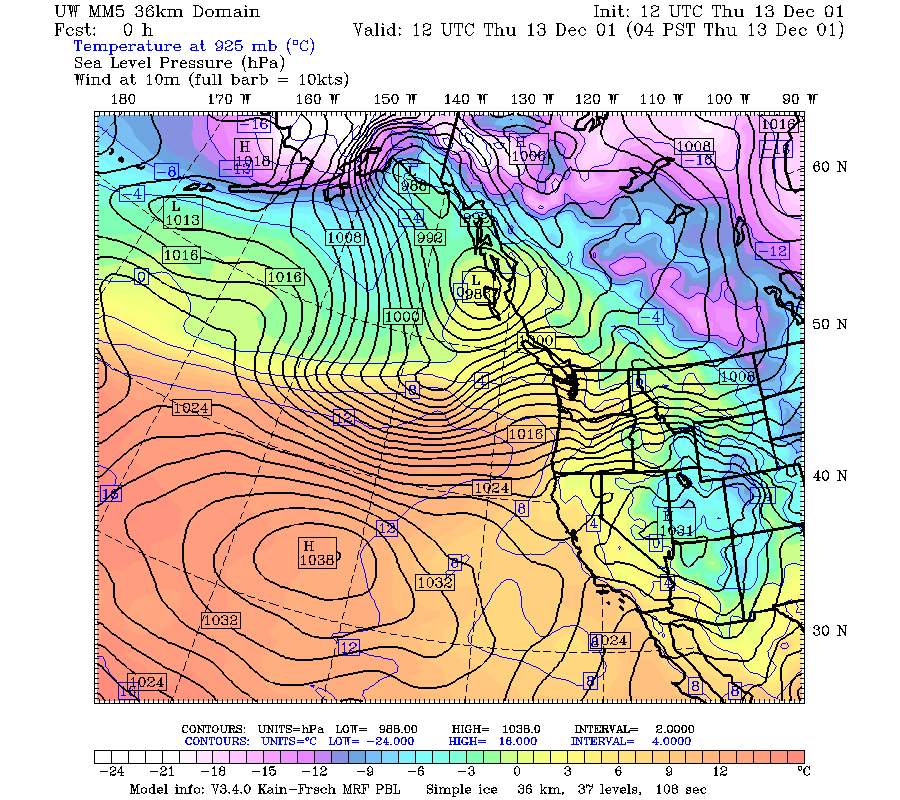
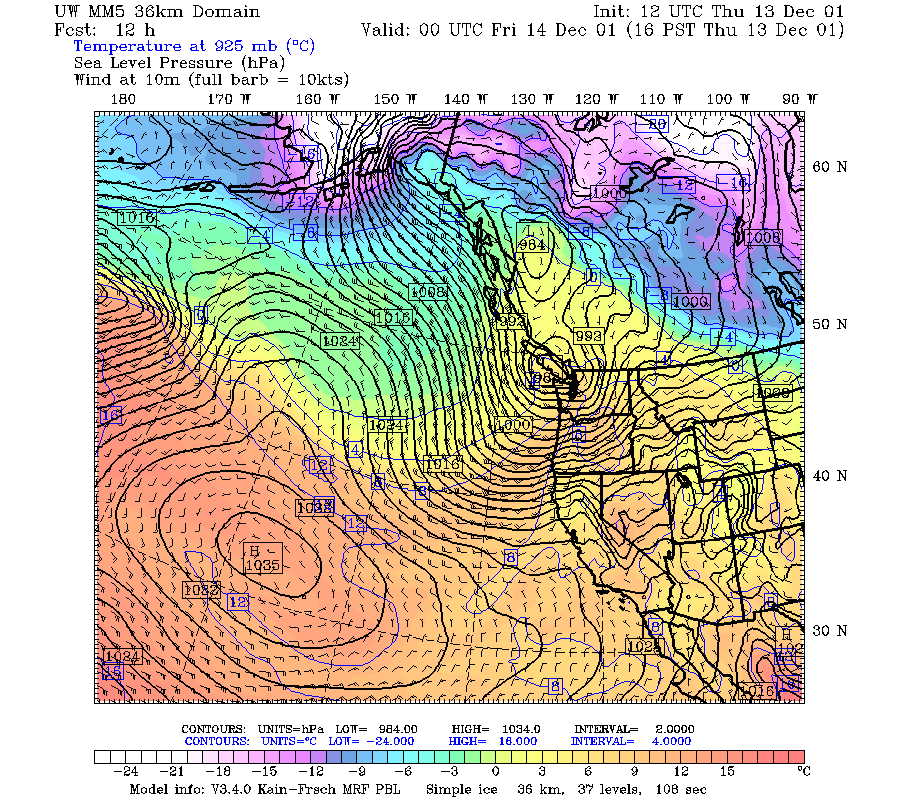
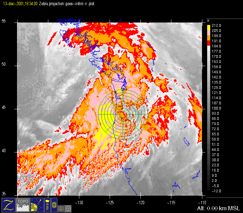
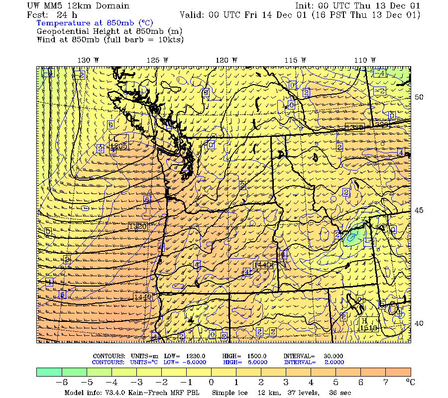
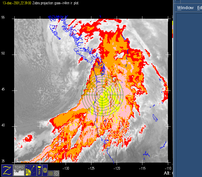
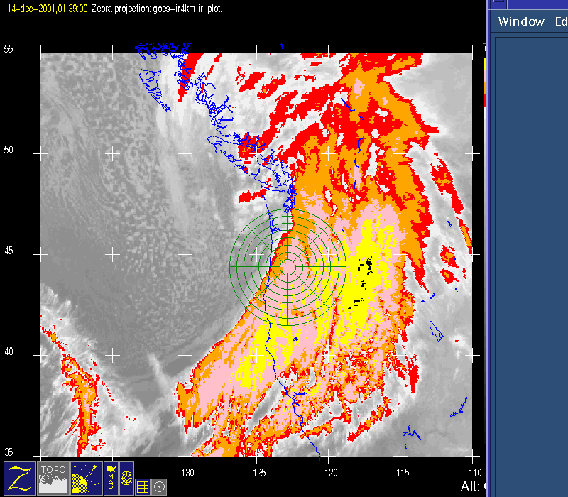
A rapidly deepening 500-mb short-wave trough approached the Pacific Northwest between 1200 13 December and 0000 14 December 2001 (Fig. 1a, Fig. 1b). During this period the surface cyclone rapidly deepened from 997 to 983 mb as it approached Vancouver Island (Fig. 2a, Fig. 2b). Meanwhile, a well defined baroclinic cloud shield was moving over the West Coast by 1900 UTC (Fig. 3), which was a little faster than forecast by the operational models. The 0000 UTC 13 December AVN numerical model run seemed to have the best timing for this event (not shown).
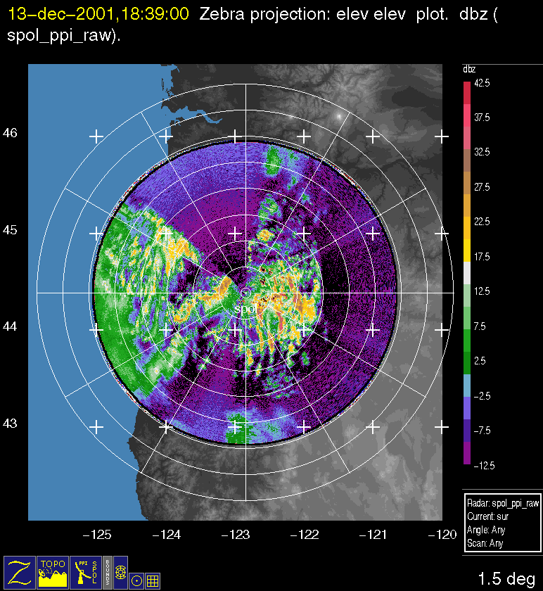
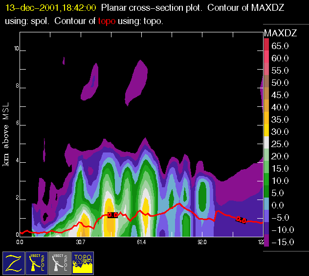
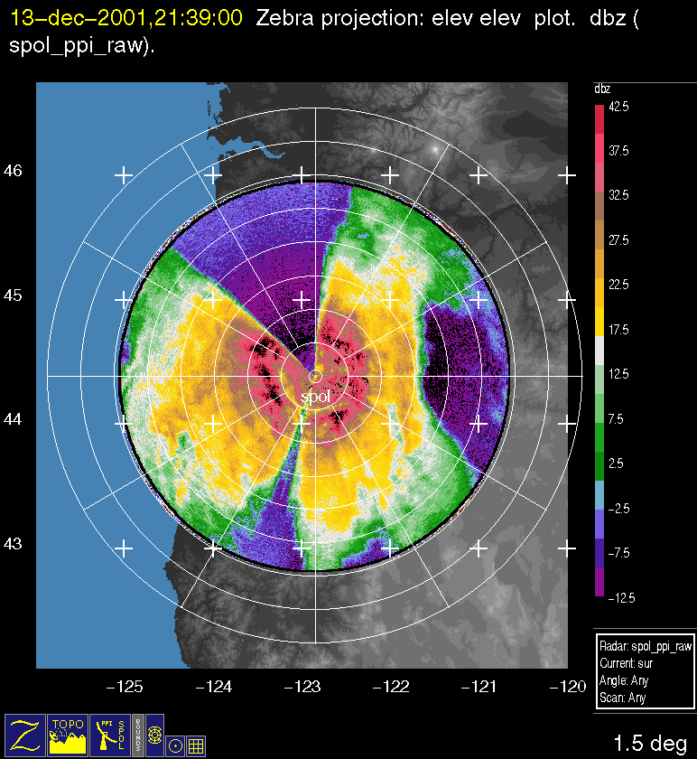
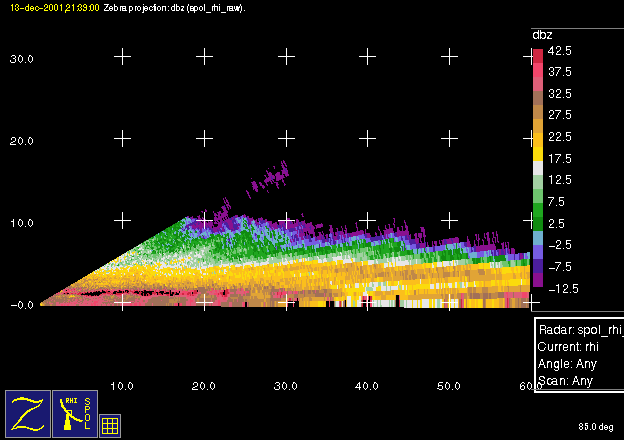
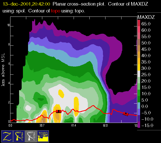
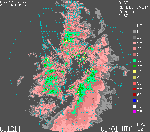
Before the start of the IOP at 1900 UTC, the precipitation was somewhat convective over the windward slope, with interesting north-south parallel bands over the barrier (Fig. 4). The convective plumes to 4 km ASL seemed to be situated near the various ridges along the western Cascades (Fig. 5). By 21:39 UTC widespread heavy stratiform precipitation was occurring over the IOP site (Fig. 6), with a well defined bright band to 45 dBZ near 2 km ASL and cloud tops above 8 km (Fig. 7). There was tremendous cross-barrier flow at 850 mb (Fig.8). As a result, there was significant orographic precipitation enhancement over the windward slopes around this time (Fig. 9), with an interesting area of reflectivity enhancement sloping downward from 4 to 2 km ASL from the first set of windward ridges. In addition, there was significant precipitation shadowing in the lee, an ice overhang above 7 km ASL, and low-level precipitation spillover in the immediate lee of the crest.
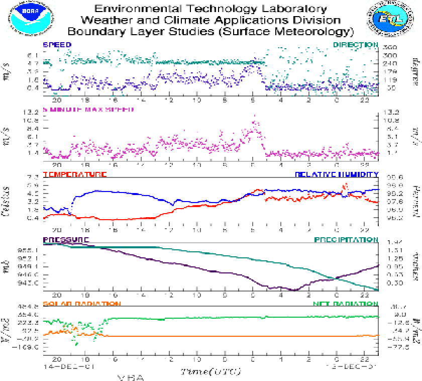
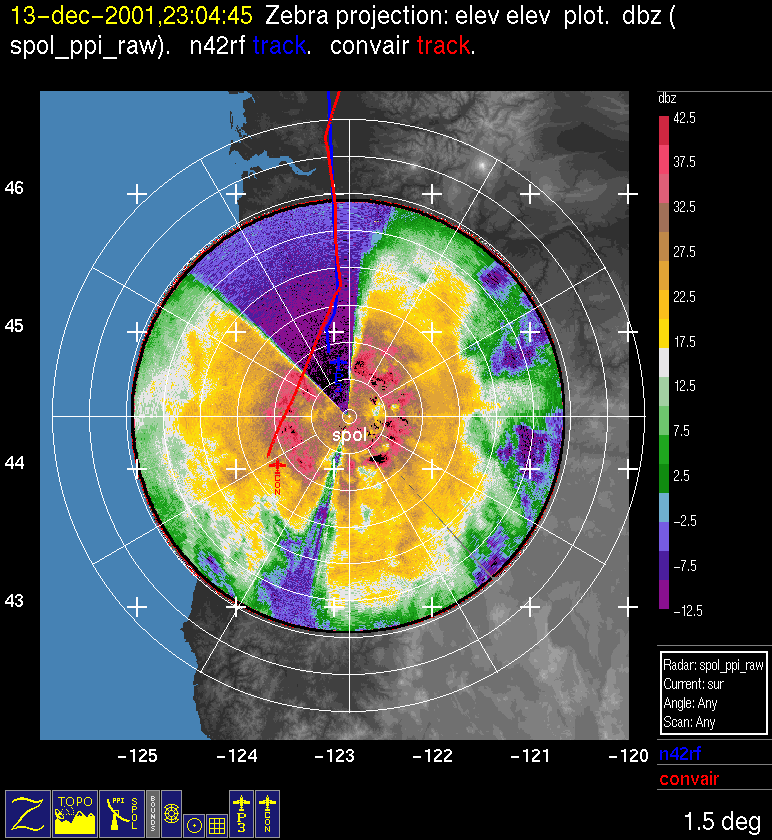
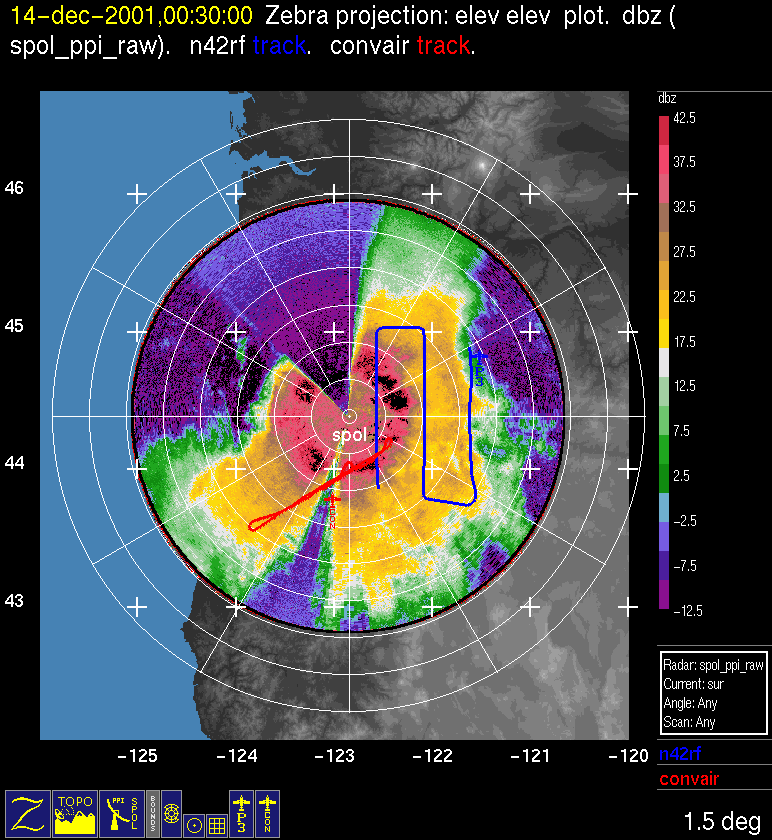
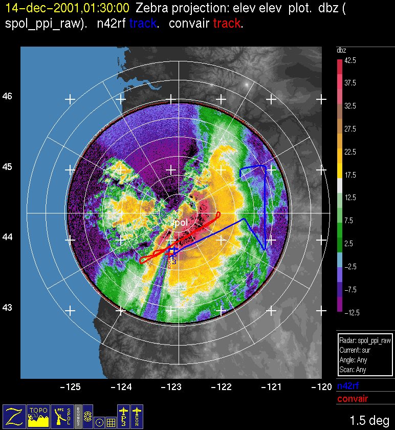
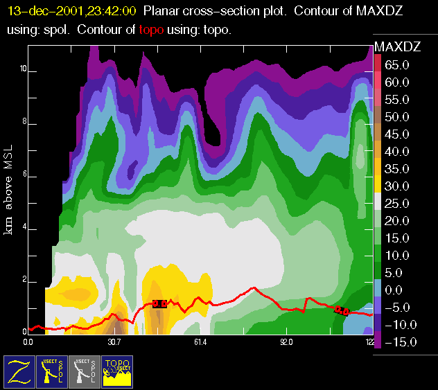
The P-3 and Convair reached the study area at about 2300 UTC. At this time there was still widespread stratiform precipitation. The P-3 successfully completed the full doppler north-S patterns between 2300 and 0100 UTC (Fig. 10a, Fig. 10b). During this period, the precipitation turned slightly more convective aloft (Fig. 11). This could also be seen on IR satellite, with the "ragged" area of cold cloud tops over the study area (Fig. 12). There was also significantly more precipitation in the lee at 2300 UTC compared to two hours ago (Fig. 9, Fig. 11), therefore allowing the P-3 to complete all north-south Doppler legs. Meanwhile, the Convair executed SW-NE flight tracks descending down from around 5.5 km ASL. Winds at the S-Pol radar site were gusting strongly. The peak gusts gradually increased from 30 to 37 m/s (the absolute peak value) during the period of about 2300 UTC 13 December through 0100 UTC 14 December. (Exposure of the anemometer was not ideal, so these values are only an indication of the actual speed. In any case it was exciting to be there!)
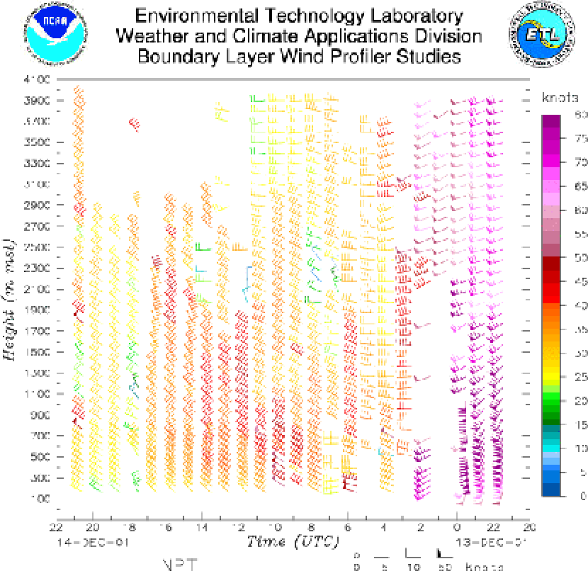
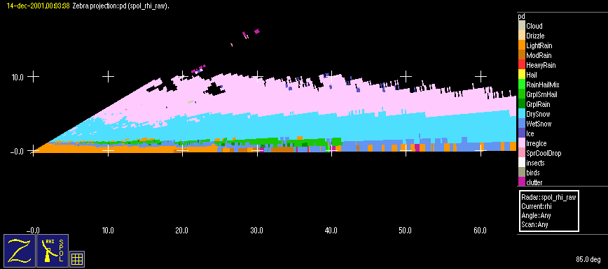
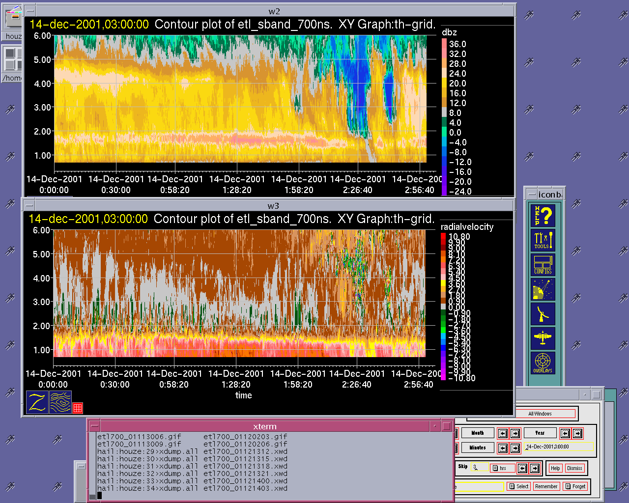
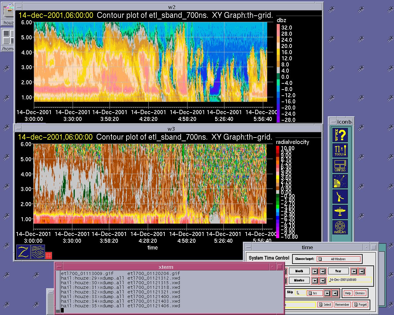
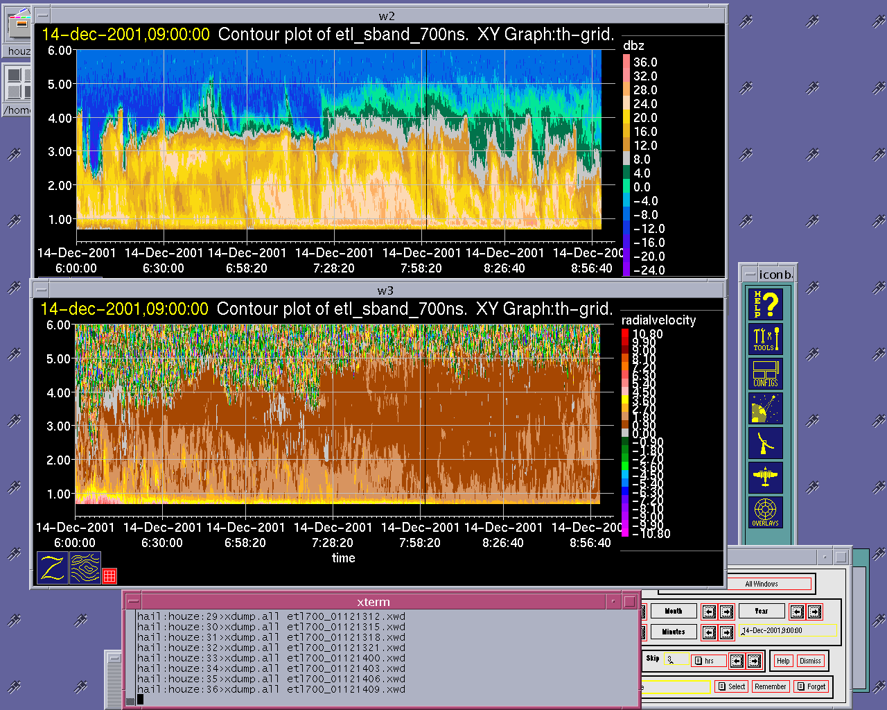
At 0000 UTC, the S-Pol particle identification algorithm indicated graupel above the bright band over an extensive region of echo (Fig. 17). The ETL S-band profiler showed a deep continuous layer of echo with a bright band at about 1.7 km AGL between 0000 and 0300 UTC (Fig. 18a). The radial velocity data in this figure showed a considerable region echo between 2 and 3.5 km AGL in which the radial velocity was zero or upward, indicating updraft of a meter per second or more. The pattern showed alternating convective scale cells of upward velocity, just above the melting layer. This pattern is consistent with the appearance of graupel at this level in the S-Pol particle identification field. The apparent upward vertical air motions were greatest when the cold air came in and the bright band dropped about 0200 UTC. After 0300, the S-band profiler showed the bright band drop eventually to the ground in the postfrontal period (Fig. 18b, Fig. 18c). Bob Houze and Brad Smull visited the S-band profiler site on the morning of the 14th and found a few inches of snow on the ground (Fig. 19a). Snow was falling while they were at the site, and Bob's dog Schaefer collected some aggregates (Fig. 19b).
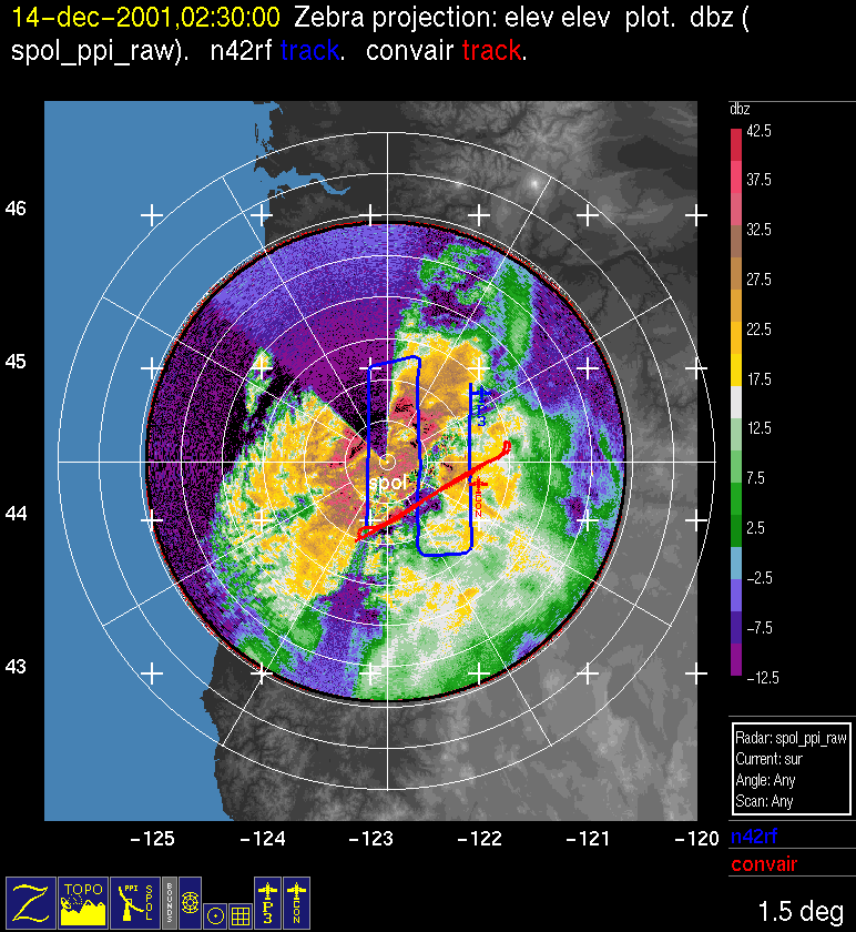
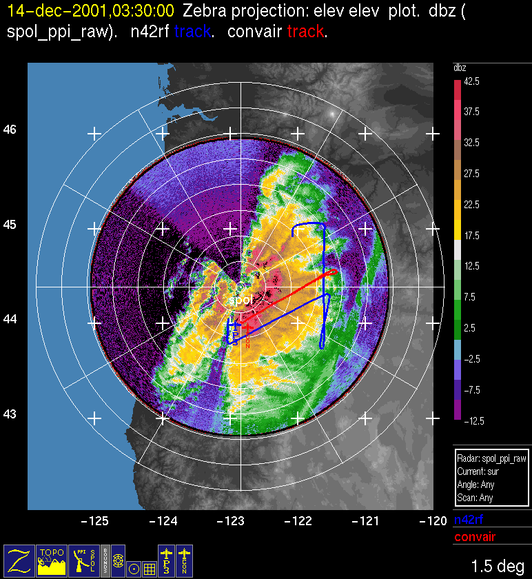
The P-3 began its second set of north-south Doppler legs along the lower windward slope by 0130 UTC. During this second set of legs the back edge of the deep upper level cloud/precipitation shield was moving across the study area (Fig. 13), while a second band was moving in from the west (Fig. 14, ). The P-3 continued to fly over the windward slope as these frontal precipitation bands moved across the region (Fig. 10c, Fig. 10d, Fig. 10e). The surface front made landfall at the coast shortly before 0300 UTC (Fig. 15).With the passage of the upper-level frontal band the winds diminished at flight level (2-3 km ASL) from near 40 m/s to 30 m/s but with no apparent wind shift and no surface frontal passage was reported yet. The precipitation character also turned more convective, with tops 4-6 km ASL. The P-3 encountered some lee wave activity at 0226 UTC and saw dramatic evidence of precipitation spillover to the north of Santiam Pass at 0232 UTC. The P-3 did not complete easternmost north-south leg because there was limited precipitation downwind of the Cascades.
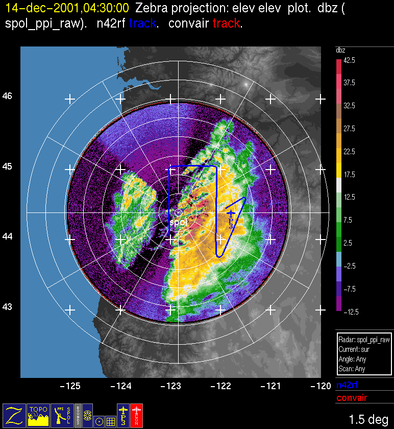
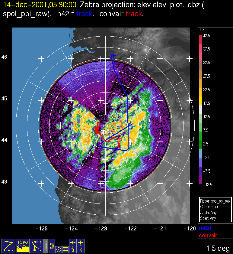
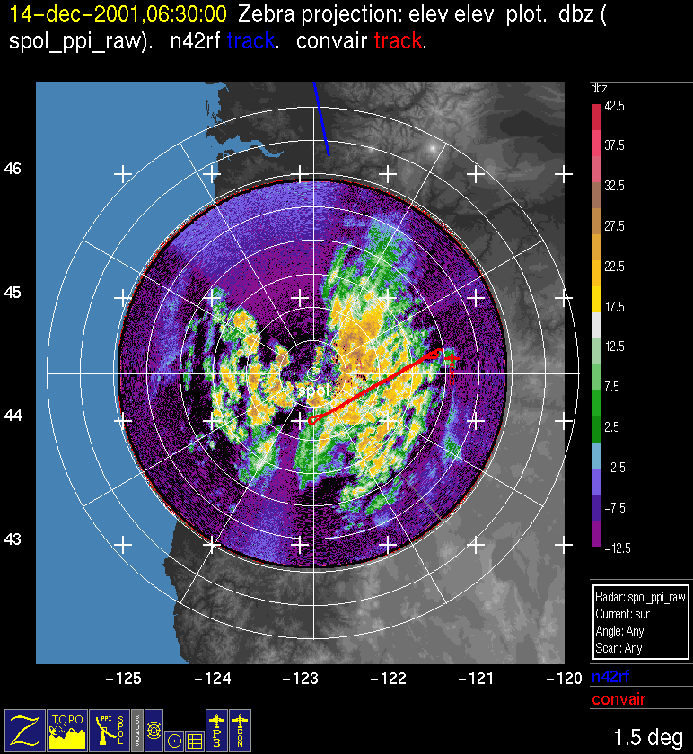
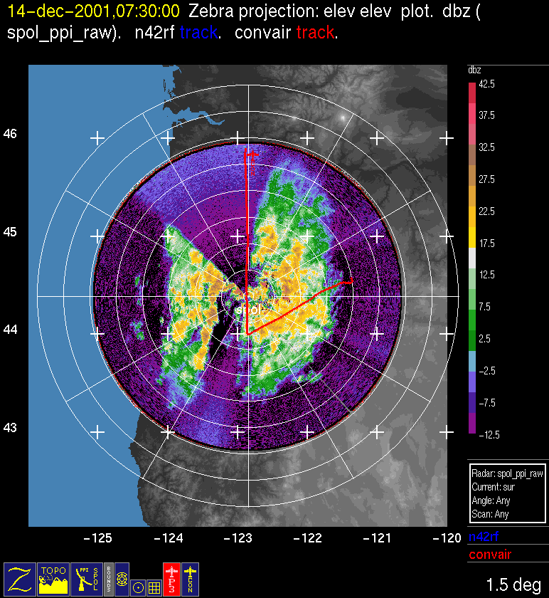
As the Convair began its second mission around 0400 UTC, the P-3 executed a NE-SW cross mountain transect over Santiam Pass at 10 kft (Fig. 10f). The surface front reached the study area at McKenzie Bridge by 0430UTC (Fig. 16). At 0500 UTC, scientists aboard the P-3 reported seeing a well defined orographic cloud extending 20-30 km upwind of Santiam Pass, to about 4.5 km AGL. The S-Pol radar during this time period showed SW-NE oriented wavelike bands of echo within this orographic cloud (Fig. 10g). The P-3 ended its mission at 0514 UTC, after completing its final south to north Doppler leg just west of Santiam Pass. The Convair continued to fly in postfrontal convection on the windward slopes till after 0730 UTC (Fig. 10h, Fig. 10i).
Convair-580 Summary
UW Flight Number:
1900
Period of Flight:
2131 UTC 13 December-0327 UTC 14 December 2001
Main Accomplishment of Flight:
Profile from 20,000 to 14,000 ft in southwest-northeast direction over Oregon Cascades in precipitation associated with main rainband of a strong cold front. (P-3 did "lawnmower" flight pattern for air motion measurements.) Convair-580 landed in Eugene, Oregon.
Instrument Problems:
PMS 2-D cloud probe erratic.
Flight Scientist:
Nick Bond
Approximate UTC Timeline (Local time= UTC-8 hours) Activity for UW Flight 1900:
2131 |
Engines on. |
2136 |
Out of blocks. |
2143 |
Takeoff. |
2203 |
Ferry in constant precipitation 2-DC probe down. |
2218 |
Winds 250˚ @ 28 m s–1 (15,000 ft). |
2220 |
2-DC back up but images look bad and suspiciously low concentrations. |
2230 |
Trying to restart 2-DC probe system. |
2244 |
HVPS temporarily down. |
2249 |
Larger crystals on HVPS. |
2304 |
2-DC looking okay. |
2322 |
At southwest starting point; begin first run, 20,000 ft, wind 250˚ @ 45 m s–1, T = –18˚ to –19˚C. |
2334 |
End of first leg. |
2338 |
Second leg heading southwest (20,000-18,000 ft). |
2352 |
No visual sign of back edge of band. |
2357 |
End of second leg. |
2359 |
Starting third leg heading northeast, 18,000 ft, wind 245˚ @ 45; T= –16˚ to –17˚C. |
0005 |
S-Pol and P-3 reporting echo tops of 7 & 8 km; latter seems more likely. |
0012 |
End of third leg. |
0015 |
Start of fourth leg (18,000-16,000 ft). |
0025 |
Everything working fine; appears to be low LWC (~0.01 g/m3). |
0035 |
Wind speeds dropping off 42 to 32 m s–1. |
0039 |
End of fourth leg. |
0041 |
Start of fifth leg heading northeast, 16,000 ft, wind 250˚ @ 31; T = –14˚ to –16˚C. 2‑DC looks kind of bad (will cycle power). |
0057 |
End of fifth leg. |
0101 |
Start sixth leg, head southwest, 16,000-14,000 ft. |
0120 |
A bit more intense precipitation, stronger winds and turbulence at southwest end of leg. End of sixth leg; clear slot at flight level right at end. |
0130 |
Start of seventh leg, heading northeast, 14,000 ft, wind 250˚ @ 40 m s–1; T –12˚ to –13˚C. Light to occasionally moderate chop at southwest end of leg. |
0141 |
Much smoother ride. |
0145 |
End of seventh leg. |
0148 |
Start of eighth leg heading southwest (14,000-12,000 ft). |
0149 |
Locally enhanced winds over Santiam Pass (~48 m s–1). |
0200 |
Some riming and small patches of high LWC. |
0217 |
End of eighth leg. |
0221 |
Start of ninth leg heading northeast, 11,000 ft, wind 255˚ @ 32 m s–1, T ~–8˚C. |
0228 |
Hitting some clear patches. |
0229 |
2-DC out then back. |
0237 |
End of ninth leg; considerable precipitation in lee of Cascade crest (aloft). |
0240 |
Start of tenth leg (stepped descent). |
0243 |
Apparently cracked a window. Short patches without precipitation in lee of crest, 10,000 ft, T ~–6˚C. |
0257 |
Hitting moderate chop. |
0304 |
Shed ice on window. |
0309 |
End last leg; heading for Eugene. |
0324 |
Landed at Eugene. |
0327 |
Engines off. |
UW Flight Number:
1901
Period of Flight:
0438-0815 UTC 14 December 2001
Main Accomplishment of Flight:
Takeoff from Eugene, Oregon. Profile across Santiam Pass in same storm system as UW Flight 1900 but in postfrontal conditions. (P-3 up only during initial portion of flight).
Instrument Problems:
-
Flight Scientist:
Nick Bond
Approximate UTC Timeline (Local time= UTC-8 hours) Activity for UW Flight 1901:
0438 |
Engines on. |
0450 |
Takeoff. |
0500 |
CCN instrument on. |
0505 |
Winds at 3,000 ft 280˚ @ 18 m s–1. |
0520 |
Broke off level work & climbing. |
0521 |
Many parameters not updating. |
0526 |
Hitting up to 0.4 g/m3 LWC and sizable ice crystals. |
0532 |
Heading for Santiam Pass. Cloud below 14,000-15,000 ft. |
0533 |
PVM zeroed. |
0536 |
Skimming tops at 13,700 ft. |
0540 |
Lighter but still continuous precipitation in lee until just before endpoint. |
0541 |
End of first leg. |
0545 |
Start second leg, heading southwest (13,700-12,000 ft). |
0547 |
Spotted some capped columns. |
0555 at 44˚17'/122˚9'. |
Out of most precipitation. |
0609 |
End of leg 2; continuous precipitation in last portion of leg. |
0613 |
Begin third leg heading northeast, 12,000 ft, wind 270˚ @ 17 m s–1. |
0620 at 44˚16'/122˚11' |
Winds now 245-250˚ @ 25 m s–1. |
0625 |
Precipitation cut off in immediate lee (some occasional bursts). |
0629 |
End of third leg. |
0633 |
Starting fourth leg (12,000-10,000 ft). |
0636 |
Sizeable patches of precipitation in lee. |
0643 |
Dropping to 10,000 ft west of pass. |
0649 |
Large flakes at ~9,000 ft and T ~–10˚C. |
0654 |
Dropping to 6,000 ft, columns appearing. |
0658 |
End of fourth leg; some needles near end. Heading to Paine Field. |
0706 |
Ascent for ferry heading due north over S‑Pol radar, precipitation up to 166. |
0810 |
Landed. |
0815 |
Engines off. |
P-3 Summary
P-3 Flight Number:
011213H, Improve 05
Period of Flight:
2040 UTC 13 December-0611 UTC 14 December 2001
Main Accomplishment of Flight:
-
Instrument Problems:
-
Flight Scientist:
Brian Colle
Approximate UTC Timeline (Local time= UTC-8 hours) Activity for P-3 Flight 05:
204023 UTC (47.90025, -122.28064) 99.084°, 972.9 mb, 3.0 m Engine Start. Wind 198o@2.4 kts. T=6.4 oC. Td=6.3 oC Psfc=973
204606 UTC (47.90031, -122.28116) 337.734°, 972.7 mb, 9.0 m Block Out
205210 UTC (47.92112, -122.28416) 358.712°, 973.6 mb, 7.0 m Radar up
205238 UTC (47.92168, -122.28316) 83.813°, 973.3 mb, 8.0 m One hour delay called. Number one start valve problem. Heading back to the hangar.
205850 UTC (47.90800, -122.28348) 177.899°, 972.1 mb, 9.0 m Radar down.
215401 UTC (47.90053, -122.28056) 91.433°, 969.3 mb, 3.0 m Engine Start. Variable light wind 170-250o
220054 UTC (47.90047, -122.28058) 176.032°, 968.9 mb, 3.0 m Block out
T=7.1;Td=6.8. Wind on taxiway 179@13.9. Psfc=969.5
220921 UTC (47.90670, -122.28555) 179.077°, 970.8 mb, 5.0 m Take off.
221213 UTC (47.81314, -122.35242) 276.158°, 882.5 mb, 839.0 m Radar starting up.
222037 UTC (47.53315, -122.66292) 193.810°, 706.0 mb, 2696.0 T=3.9 oC; Td=3.9 oC; Z=9700m. Needle and aggregates.
222600 UTC (47.26814, -122.87079) 220.686°, 628.9 mb, 3626.0 m Excellent radar coverage. Precip. highly stratiform with clearly visible bright band.
224401 UTC (46.10787, -123.01904) 177.581°, 560.7 mb, 4382.0 m Still very good radar coverage. Temperature warming as we move south. T= -12.4 oC. Dendrites.
225323 UTC (45.47267, -122.97414) 180.315°, 564.4 mb, 4474.0 m Start descent to 6000ft. Wind 255o/57 kts at 14250.
-8C: 12200ft. Dendrites. Few needles and needle clusters. Wind 252o/59. RH 100%
-4C: 9900ft. More needles. Wind 249o/66 kts. Area of moderate chop.
225855 UTC (45.12265, -123.00816) 204.683°, 731.3 mb, 2497.0 m Freezing level. 7650Ft. wind 241o/59 kts. Moderate chop.
230244 UTC (44.94910, -123.06636) 175.970°, 798.0 mb, 1732.0 m Point A. 6450Ft AMSL. T1.6. RH=100%+. Wind 238o/77 kts. Moderate chop. Convective cell about 15km ahead.
230558 UTC (44.78348, -123.05608) 179.093°, 798.2 mb, 1758.0 m 6450 ft. 60 mile from PT F. Wind 235o/70 kts. T=1.9. Mainly liquid water. Some aggregated melting ice. Good radar coverage. Mainly stratiform with some embedded cells. Chop still moderate.
231338 UTC (44.37650, -123.03514) 178.358°, 798.8 mb, 1739.0 m 35 miles from F. Whole AF leg at 6450 feet so far. T:1.2 oC, wind 235o/69 kts. Gust to 80 kts. Hurricane force winds just reported by pilot:)
231934 UTC (44.07651, -123.02928) 180.249°, 798.4 mb, 1727.0 m Surface visible. Cloud base approx. 6100.
Traffic seen. Climbing to 8000 early.
232047 UTC (44.00908, -123.02951) 180.162°, 797.9 mb, 1702.0 m False alarm. Staying at 6450ft. 12Miles from F. T=1.4 oC, wind 238o/74 kts. Smooth air
232439 UTC (43.81005, -123.02853) 181.999°, 797.1 mb, 1667.0 m At point F. Climbing to 8000ft. T=1.5 oC, wind 236o/68 kts.
AF Leg took 23mins 40 secs
FreeUTCing:7400ft.
Level 8350ft. T=-1.6 oC. Moderate chop. Aggregates
232753 UTC (43.77461, -122.69901) 91.271°, 743.1 mb, 1485.0 m Radar down. Wind 233o/68 kts
233127 UTC (43.96507, -122.56126) 357.398°, 742.8 mb, 2008.0 m Just north of G. 62 miles to B. 8350Ft. T=-2C. Wind 234o/68.
F->G : 3min 55sec
233349 UTC (44.13544, -122.56654) 359.674°, 742.9 mb, 2094.0 m Radar up. 50 miles from B. T=-2.6 oC; Td=-1.5 oC, wind 235o/70. Moderate chop. Td>T for some time now. Supersat water expected but some values look a little too sat. Prob. OK but worth checking. Radar coverage is still excellent. Some cellular echoes to the west.
233827 UTC (44.48302, -122.56723) 357.889°, 743.0 mb, 1595.0 m Microphysics down. 30 miles from B
234526 UTC (45.00491, -122.56227) 28.705°, 741.7 mb, 1994.0 m At point B. G->B leg done at approx 8350ft. G->B took: 16mins 30secs
T=-1.7. 240/75. Making the turn and climbing to 11K.
Physics back up.
234746 UTC (45.03534, -122.29631) 90.753°, 677.8 mb, 1969.0 m 10800: T=-5.9 oC, wind 249o/80 kts
Note: -4 oC at 9780 feet. Needles, aggregates and some rimed dendrites
234912 UTC (45.03246, -122.12306) 111.936°, 660.5 mb, 2136.0 m At point C. 11360 feet. T= -6.6 oC. Td= -7 oC, wind 247o/75.
B->C 4 mins.
235147 UTC (44.88167, -122.08351) 178.777°, 660.9 mb, 1787.0 m Predominately needles. Lots of them. T= -6.8 oC. Smooth air
235624 UTC (44.61497, -122.08304) 179.572°, 661.0 mb, 2333.0 m Still almost all needles. Starting to get a some ice on the wing.
At 41 miles from H T= -6 oC. Td= -7.2 oC, wind 250o/83.
000331 UTC (44.20911, -122.08203) 179.647°, 661.0 mb, 2073.0 m Microphysics down again. Enhancement over terrain ridges seen on radar.
000955 UTC (43.81623, -122.08873) 171.254°, 661.2 mb, 1817.0 m C -> H leg completed in 21min 3secs. Leg at 11350 ft. Pretty smooth leg.
T= -7.6 oC; Td= -8.3 oC, wind 257o/81
001152 UTC (43.77084, -121.89420) 98.640°, 622.8 mb, 2260.0 m H->I Climbing to 13 kft.
13380Ft: T=-10.2 oC; Td=-10.7 oC, wind 255o/82 kts
001344 UTC (43.74422, -121.66594) 98.596°, 609.9 mb, 2677.0 m At I. H->I Approx 4 mins.
T=-9.8 oC; Td=-10.1 oC; wind 254o/80. Microphysics still down.
002204 UTC (44.30367, -121.62157) 355.846°, 609.9 mb, 2946.0 m T=-9.7. Td=-10.8 oC. Wind 255o/77 kts. Very smooth air.
003200 UTC (45.02245, -121.55893) 76.014°, 613.6 mb, 2990.0 m At point D. I->D completed at approx 13380 ft. Time: 16mins 34secs
T=-8.9 oC ;Td=-13.2 oC; wind 261o/60 kts.
003213 UTC (45.02721, -121.53154) 76.456°, 618.9 mb, 2954.0 m Descending to 10000ft towards pt east.
-8 oC@12200ft
11000ft: t=-5.4 oC; Td=-8 oC, wind 255o/84 kts
003506 UTC (45.06289, -121.16113) 105.521°, 686.9 mb, 2266.0 m At Pt east. Time for D-> E 4mins 5secs.
10360Ft: t=-4 oC; Td=6.2 oC, wind 256o/80. Heading towards Pt J
Precip thinning substantially to the east
004154 UTC (44.66370, -121.13007) 178.466°, 687.4 mb, 2276.0 m Radar down. 53 miles from Pt J
004430 UTC (44.51184, -121.13329) 182.143°, 687.4 mb, 2127.0 m Radar up. 42 miles from J. T= -4.7 oC; Td=-5.2 oC; wind 250o/74 kts
004649 UTC (44.38351, -121.13603) 181.523°, 687.2 mb, 2146.0 m 36 miles from J. Slight chop.
005106 UTC (44.11162, -121.12985) 176.601°, 687.1 mb, 2032.0 m Microphysics back up.
RH is dropping rapidly in last 10 miles. Dropped 4 oC while I typed this. Now T= -2 oC, Td= -8.5 oC. No cloud particles
005526 UTC (43.86850, -121.14572) 275.722°, 676.7 mb, 1724.0 m At J. 11000. -4.1/-9.4. 251/80. E->J 20 mins 3 secs.
Heading to K and climbing to 13K
12200Ft: -6/-11.5
005922 UTC (44.04223, -121.29639) 326.311°, 610.0 mb, 2835.0 m Cloud particles observed again. Can see lee suppression on radar
010402 UTC (44.30408, -121.52985) 310.596°, 609.7 mb, 2997.0 m At K.
J->K 8mins 48 secs
011119 UTC (44.14043, -122.00313) 244.154°, 609.8 mb, 2898.0 m 49 miles from F. Huge dendrites very pristine dendrites visible.
Beautiful!
011255 UTC (44.10531, -122.10925) 246.192°, 610.7 mb, 2601.0 m Now descending slowly from 13K to 6K. 44 miles from F. Will get some descent data below:
13000: T=-10.9 oC; Td=11.1 oC; wind 255o/73 kts
12000: T=-9.1 oC; Td = -9.5 oC; wind 257o/71 kts. Big dendrites.
T=-8 oC; At UTC=11300; Td=-7.9 oC; wind 255o/65 kts.
11000: T=-7.4 oC; Td=-7.1 oC; wind 255o/65 kts
10000: T and Td= -5.4 oC; wind 256o/60 kts. Slight chop. Aggregates, rimed
t=-4; UTC=9100ft; td=-4.1; 252/52. Crystals look very rimed. Few needles appearing. Quite a lot of liquid water.
8000: t/td = 2.2/2.2 240/52. Moderate chop.
0C: UTC=6450ft Td=0.5 oC; 239/50 kts Nearly isothermal from 7100 to 6500 (0 to -0.9C). Areas of fairly severe chop.
012836 UTC (43.83696, -123.04393) 4.566°, 796.2 mb, 1684.0 m Missed the turn due to the chop! 69 miles to A. 6500 feet.
Sitting on the freezing level. Wind 237o/55 kts.
013404 UTC (44.24532, -123.02542) .590°, 796.3 mb, 1734.0 m 45 miles from A. Seem to be out of the rough stuff.
T/Td=0.7/-0.1. 231/57
014713 UTC (45.06541, -122.68637) 76.303°, 769.3 mb, 1993.0 m At A. T/Td= 0.4 oC/0.5 oC; wind 243o/62 kts. Mod. Chop. F->A approx 18min 20sec but approx as missed the turn at F. Leg done at 6500 feet.
Now heading to B and climbing to 8K. (Data taken at A, but LHS entry added between A and B
014911 UTC (45.02110, -122.54942) 187.778°, 769.2 mb, 1678.0 m At B. 7425. A->B 4mins 20 secs. T= -1.5 oC, Td=-1.2oC, wind 229o/57 kts. Moderate chop. Precip. Thinning around us but filling back in to the west.
015742 UTC (44.54487, -122.55588) 177.452°, 739.8 mb, 1603.0 m At 8450ft 45 miles from G. T/Td=-3.1 oC/-3.2 oC. Wind 239o/59 kts
020114 UTC (44.34431, -122.54181) 185.496°, 739.9 mb, 1587.0 m 34 miles from G. Just flew through a warm area. temperature rose to about -1.5 oC for same altitude (8450ft). Lots of needles seen.
020604 UTC (44.08192, -122.56676) 178.914°, 739.8 mb, 1287.0 m Moderately severe chop briefly. Precip. Seems to be filling in to our NW, with 40 dBZ on -ve tilt scan. Still very little echo directly around us. T/td= -3.2 oC/-3.6 oC, wind 240o/60kts
021123 UTC (43.78807, -122.52592) 123.970°, 710.9 mb, 2223.0 m Lots of needles. At G. T/Td=-3 oC/-5.2 oC, wind 148o/60 kts
Majority of BG flown at about 8450ft except initial part when still climbing. B->G time:22mins 10 secs.
021409 UTC (43.78519, -122.21391) 86.534°, 659.0 mb, 2452.0 m Reached H after Climb to 11400ft. T/Td=-8.4 oC/-7.7 oC. Very few cloud particles. Wind 246o/75 kts. G->H 4 mins 20sec.
021823 UTC (44.03703, -122.07861) 358.048°, 658.9 mb, 1934.0 m 58 miles from C. Radar is really thinning except to NW. T/Td=-9.3 oC/-8.5 oC; wind 238o/60 kts. Much more turbulent than first lawn mower leg.
022749 UTC (44.73656, -122.08429) 1.152°, 658.2 mb, 2190.0 m Just hit an updraft (poss gravity wave) at about 2:26:20. Jump in cloud particles and precip. At about the same time. Radar has really filled in again. Fair amount of large crystals.
023112 UTC (44.99904, -122.07504) 23.138°, 643.6 mb, 2836.0 m At point C. H->C 16 mins. Climbing to 13kft at heading to D.
023247 UTC (45.05436, -121.91560) 80.380°, 604.2 mb, 2899.0 m Levelled at 13600 and making the turn 10 miles from D. T=-13. Dewpoint sensor just failed ( possibly iced up). Slowly coming back to life. C->D 4mins 28sec
023533 UTC (45.02706, -121.60718) 171.953°, 608.1 mb, 2819.0 m Heading towards I. T=-11.6 oC (Dewpoint still all over the place). Wind 245o/60 kts. Fairly ice crystals. Td settling down to about -11.5 oC. Good radar to west. Looks like some embedded convection, thinner to the east. Hitting some more bumps. 3m/s at approx 2:40:30.
025855 UTC (43.85142, -121.65674) 9.896°, 607.9 mb, 2467.0 m Just passed I. Data at I: T/Td -12.4 oC/-12.8 oC, wind 248o/72.5 kts.
D->I 22mins 50secs. Leg done at 13473. Not doing JE leg. Now heading to K for slow descent to F. Nice dendrites.
030332 UTC (44.24029, -121.54128) 11.165°, 607.9 mb, 2920.0 m Can see upslope in radar and shallowing echo in the lee around the 20 km range ring.
030450 UTC (44.31419, -121.57469) 251.429°, 608.2 mb, 2965.0 m At K, 13460ft. Leg time: 7min 22sec. T=-11.5 oC; td=-15.9 oC; wind 251o/63 kts
030914 UTC (44.20963, -121.88518) 243.084°, 613.3 mb, 2404.0 m
13200: T/Td=-12 oC/-12.2 oC. Wind 250o/62 kts
12925: T/Td=-11.3 oC/-11.7 oC, wind 252o/67 kts
12000: T/Td=-10 oC/-10.1 oC, wind 248o/62 kts
T=-8 oC: Z=11150ft; Td=-8.8 oC; wind 250o/63 kts
11000: T/Td=-7.6 oC/-8 oC, wind 250o/60 kts. Transition to mostly needles
10000: T/Td=-6.9 oC/-6.3 oC, wind 250o/52 kts. Moderate turbulence 10100-10000.
9000: T/Td=-5.3 oC/-4.6 oC, wind 253o/51 kts. Still mod turb.
T=-4 oC: Z=8230ft; Td=-3.3 oC, wind 245o/53 kts.
8000: T/Td=-3.6 oC/-2.7 oC; wind 247o/49 kts
Rimed crystals and aggregates. Moderate turb.
6500: T/Td=-0.8 oC/-0.9 oC; wind 257o/36 kts.
Moderately severe turb. Good radar coverage. Cloud depth still about 6km.
032619 UTC (43.80268, -123.03801) 330.302°, 797.1 mb, 1651.0 m At point F. T/Td=-1.2 oC/-0.8 oC; wind 258o/44 kts
K->F 21min 45sec
033008 UTC (44.06456, -123.03282) .425°, 797.2 mb, 1699.0 m Nice view down below of Eugene! Much less precip. Here. Pretty smooth.
033239 UTC (44.23717, -123.03268) 358.915°, 797.5 mb, 1716.0 m Slight chop.
033747 UTC (44.58102, -123.03406) 359.874°, 797.2 mb, 1735.0 m Significant turb at 3:36:30. 8m/s vertical motion.
033946 UTC (44.71900, -123.03276) 359.356°, 797.5 mb, 1750.0 m Very little radar coverage at the moment. Almost no precip. A little cooler towards A too. T/Td=-2.2 oC/-2.4 oC, wind 256o/47 kts. Can see Salem
034239 UTC (44.91833, -123.03246) 357.954°, 797.4 mb, 1752.0 m Nose radar indicates a few cells ahead. And it was right!
034422 UTC (45.03324, -123.00653) 52.561°, 796.0 mb, 1760.0 m Made the turn at A. Hit a big bump. +7.5 and -10.0. Approx 3:44.
Climbed to 9500 heading to C.
Moderate to moderately severe chop. T=-6.6 oC/-6.3 oC, wind 249o/58 kts
F->A 18min 50sec.
034955 UTC (45.05311, -122.38309) 91.384°, 708.6 mb, 1851.0 m 12 miles from C 9570ft. Radar coverage increasing again as we near the crest. Now climbing to 11000ft
035157 UTC (45.05337, -122.14508) 92.811°, 658.5 mb, 2444.0 m 2.5 miles from C. 11465Ft. Making the turn. T/Td=-9.9 oC/-10.6 oC, wind 258o/55 kts. Needles and plates. Heading to H.
A-> C 8 mins 25 sec
040230 UTC (44.40169, -122.08786) 178.701°, 657.9 mb, 2129.0 m 37 miles from H. T/Td=-10.6 oC/-12 oC, wind 251o/55 kts
Moderate chop. Good dual Dopplar coverage
041230 UTC (43.75751, -122.01875) 82.840°, 644.4 mb, 1866.0 m At point H. T/Td=-10.5 oC/-10.9 oC, wind 256o/47 kts
C->H 19 min 50sec
Leg flown at 11468ft. Fairly smooth until 6 miles from H, then slight chop.
041315 UTC (43.79543, -121.95770) 25.337°, 624.4 mb, 2051.0 m Climbing to 13 kft
-14 oC@13450ft Td=-16 oC. Heading to Q at 13500ft. Good radar coverage in this area Some cells off to the right
042236 UTC (44.50196, -121.54060) 23.526°, 607.4 mb, 2810.0 m 2 miles from Q at 13500. About 5 mins ago saw amazing St.Elmos fire on the Cockpit window. Just like a plasma ball. I wonder what the ice crystals looked like.
T/Td=-14.2/-16 252/63.
042542 UTC (44.56725, -121.62730) 239.508°, 618.9 mb, 2943.0 m Descent to 10500:
12000:T/Td= -11.2 oC/-12.2 oC, wind 263o/55 kts. Slight chop.
11000: T/Td=-9 oC/-10.8 oC, wind 261o/51 kts
Moderate chop at 10500ft.
043048 UTC (44.42516, -121.95438) 240.069°, 684.9 mb, 1820.0 m Moderate to moderately severe turbulence.
043339 UTC (44.34417, -122.14482) 237.510°, 683.0 mb, 1718.0 m Fairly high frequency turbulence. Radar sketchy to right (NW), but good coverage to left (SE) with some embedded convection.
043710 UTC (44.24981, -122.36620) 240.271°, 684.1 mb, 2100.0 m 36 miles from P. Much calmer air. T/Td=-9.7 oC/-14 oC, wind 246o/56 kts. Almost no precip at flight level
043912 UTC (44.19259, -122.49872) 239.014°, 683.5 mb, 2423.0 m More moderate chop. 28 miles from P. Main echo still off to left, much less to the right, though it seems to be weakening everywhere now especially forward scan.
044740 UTC (43.94512, -123.06372) 221.651°, 683.9 mb, 2881.0 m At P T/Td=-10.5 oC/-12 oC, wind 250o/38 kts. QP leg 24min 25sec.
Climbing to 11500 feet heading to pt H.
045132 UTC (43.85425, -122.72160) 98.068°, 660.9 mb, 2591.0 m Experiencing some moderate chop. 4:48:37 VV=7m/s.
22 miles from H. UTC=11400ft. T/Td= -12.1 oC/-12.8 oC, wind 246o/58 kts
045647 UTC (43.79759, -122.12804) 73.223°, 660.3 mb, 2164.0 m 2.5miles from H. T/Td=-11.4 oC/-14.2 oC, wind 253o/65 kts
PH leg: 9mins 25 secs. Starting H->C at 11400ft
050117 UTC (44.11195, -122.08255) 359.948°, 660.1 mb, 1752.0 m Moderate turbulence. Radar really filling out again to east with terrain enhancement. Can see echo sloping up the terrain.
050656 UTC (44.52946, -122.08780) 359.636°, 659.5 mb, 2335.0 m Short burst of dendrites and/or hex columns interrupting the previously boring crystals. T=-12.2 oC; Td=-12.8 oC
051019 UTC (44.78056, -122.08989) .205°, 660.2 mb, 2236.0 m Haven't seen a detectable wind shift but its getting colder along this leg. At H it was -11.4 oC/-14.2 oC. Now it is –13 oC/-13 oC. Humidity is fluctuating rapidly between supersaturated and about 90%.
051328 UTC (45.00151, -122.08720) 359.738°, 660.1 mb, 2475.0 m t C: UTC=11400ft A->C 16mins 35secs
T/Td=-12.5 oC/-13 oC. Wind 246o/47 kts.
Now climbing out to cruising altitude and heading home.
051656 UTC (45.22256, -122.20308) 334.582°, 576.4 mb, 3772.0 m
14000: T/Td=-19.1 oC/-19.1 oC
15500: T/Td=-21 oC/-27.6 oC
16500: T/Td=-24 oC/-25.5 oC, wind 242o/49 kts
Level at 16600: T/Td=-23 oC/-27 oC, wind 246o/47 kts
Above precip. But a fair depth of ice still overhead.
055332 UTC (47.74178, -122.55676) .859°, 853.7 mb, 1118.0 m Heading into final approach. 4700 feet. Starting to hit some chop. Wind 270o/10 kts, not seeing the expected strong southerlies yet.
4000ft: wind 270o/28 kts. 1.6C VV:+- 5m/s
3500ft: wind 300o/95.3 kts
3000ft: T/Td=3.2 oC/2 oC, wind 297o/11 kts
2500ft: T/Td=4 oC/3.4 oC, wind 297o/2 kts
2000ft: T/Td=5.3 oC/3.2 oC, wind 199o/8 kts
060951 UTC (47.90208, -122.28159) 104.958°, 964.8 mb, 10.0 m Landed about 0607UTC. Taxi to hangar.
061130 UTC (47.90023, -122.28058) 261.763°, 964.9 mb, 10.0 m Engines off.
S-Pol Radar Summary
The S-Pol radar was run continuously in the same mode of operation for the entire length of the field project.
Summary of Mobile Upstream Sonde Launches
Launch times at: Creswell, OR, Lat: 43.9200, Lon: -123.0250, Elev: 165 m
2101 UTC 13 Dec
2356 UTC 13 Dec
0405 UTC 14 Dec
0643 UTC 14 Dec
Summary of Leeside Sonde Launches
Launch times at: Black Butte Ranch, OR (a.k.a. ISS-3), Lat: 44.379, Lon: -121.679, Elev: 1027 m
2100 UTC 13 Dec
2211 UTC 13 Dec
0000 UTC 14 Dec
0300 UTC 14 Dec
0600 UTC 14 Dec
Summary of NWS Sonde Launches from Salem (SLE)
Launch times:
2100 UTC 13 Dec (special)
0000 UTC 14 Dec (standard)
0300 UTC 14 Dec (special)
0600 UTC 14 Dec (special)
Summary of Snow Crystal Ground Measurements
Measurement times:Every 15 minutes from
2100 UTC 13 Dec-0715 UTC 14 Dec (at Ray Benson Sno Park)
